Causes of Flooding in Bangladesh
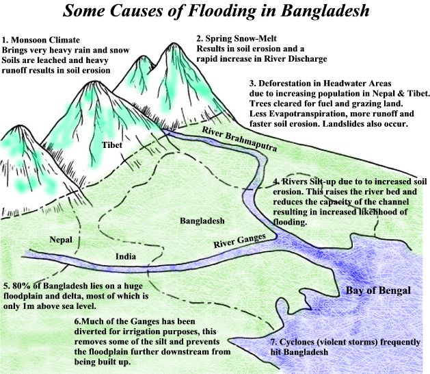
Photo: CGZ
Bangladesh is one of the world most densely populated country and one of the most susceptible countries to flood disasters. It also has one of the three most powerful rivers passing though it Ganges, Meghna and Brahmaputra. About one half of the land area in Bangladesh is at an elevation of less than 8 meters above sea level. Up to 30% of the country has been covered with flood waters. In 1991 more 200,000 deaths resulted from flooding and associated tropical cyclones. (more…)
Floods In Bangladesh
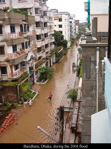
Photo: Raiyan Kamai
Baridhara is a zone designated for diplomats, high ranking civil and military officials, and politicians in Dhaka, Bangladesh. Most embassies are located in Baridhara and people works in embassies (foreigners) lives here. It is an affluent part of Bangladesh which is evident by local infrastructures. It is also the location of the American International School of Dhaka (most expensive school in Bangladesh).
Bangladesh, which has 156 million people (July 2009 est.) and the area is 144,000 sq km including 10,090 sq km of water, so the total land is 133,910 sq km. Bangladesh is one of the most vulnerable places to climate change. As the sea level slowly rises, this nation that is little more than a series of low-lying delta islands amid some of Asia’s mightiest rivers – the Ganges, Jamuna-Brahmaputra and Meghna. Bangladesh has more than 150 rivers cross Bangladesh and almost all rivers flows close to the danger marks during flood time. Experts said that major rivers like Jamuna and Padma could overflow at anytime if heavy rainfall occurs and continues for a week. (more…)
The Arctic Ice Cap
The Arctic ice cap shrank so much that waves briefly lapped along two long-imagined Arctic shipping routes, the Northwest Passage over Canada and the Northern Sea Route over Russia. Complicating the picture, the striking Arctic change was as much a result of ice moving as melting.


A host of Arctic scientists say it is too soon to know if the global greenhouse effect has already tipped the system to a condition in which sea ice in summers will be routinely limited to a few clotted passageways in northern Canada.


As we move along with those pictures we can see the Arctic ice caps are melting but very fast. In 2005 the scenario was much worst.

All those pictures were taken on September 16th each year, which is right after the summer. Summer 2007 shows a record breaking loss of arctic sea ice. Experts attribute the changes to the interaction of wid. Weather, ice drift, ocean current and greenhouse gases. (more…)
Population and Environment
World population is increasing day by day and our environment is changing day by day. We are changing our living style to eating habit. This video is a great example of it.
This video was made in fall 2006, University of Oregon, Geography Department.

240 comments